Into the Field: Part 2, Hercules Dome
- Annika Horlings

- Mar 8, 2020
- 16 min read
Updated: Apr 17, 2020

It is December 26th, 2019. We are aboard a twin otter aircraft, soaring through the Antarctic sky between the South Pole and our destination, Hercules Dome, about 400 kilometers to the grid west. There is a tangible excitement amongst the team. We have anticipated this moment for a long time - many weeks of waiting, preparation, and anticipation in Antarctica. Realistically, though, we individually have been planning for transcending into the Antarctic deep field for almost a year. I look out the window of the aircraft at the vast icy expanse that seems to extend into eternity. I take a mental note of the feeling of flying further into the infinite and the reality of true Antarctica, so remote, so distant from any form of life or civilization or landscape we are used to. About an hour and a half passes by, and suddenly I sense the plane turning. We are here. We all scramble to peer out to get a glimpse of the field camp that we will be descending upon, the field camp that Knut and Andrew inhabit, and our future residence. I spot it. I discreetly shiver. I am overcome by a feeling of eeriness at seeing the camp from hundreds of feet above with our sole two team members, ready to greet us, amidst the great expanse of the ice sheet. Oh, how insignificant we truly are within this landscape. And, despite imagining this moment, the beginning of our journey in the deep field, for so very long, there was so much I couldn’t have anticipated, so much I couldn’t have imagined, even within that moment. After several passes over the groomed runway, the twin otter landed smoothly, and we stepped out onto the place we would call home for the next 28 days.

Hercules Dome camp as seen from the twin otter. Photo credit: Rodney Fishbrook.

Camp at the end of the season, illustrative of the three main types of tents: Scott tent (foreground), mountain tent (middle), and Arctic Oven (background). Notice the large snow drifts that formed through the season, caused by wind blowing around the tents and accumulating on the leeward side.
Daily Life
What did a typical day look like at our camp at Hercules Dome? Well, life at camp was variable, depending on who was operating which instruments in the field, on the weather, and on where we were at in our fieldwork timeline. Generally, though, the day would begin by awaking at 6:30 am New Zealand time (though, due to the constant daylight, this designation felt quite arbitrary), then summoning the courage and energy to pull ourselves out from the warm “snowy owl” sleeping bag within our individual air-tight mountain tents. Then we would slip into our cold-weather clothes, squeeze out the tent entrance, and assemble at the main large Arctic Oven kitchen tent by 7:00 am. On the way, we would likely hit the bathroom tent – which surrounded a deep hole in the ice that had been melted by a heater, with a “Johnson box” secured on top. For breakfast, we would eat oatmeal, bagels, or, on a luxurious day, pancakes, eggs, and other delicious cooked items. Cooking was rather easy on two large Coleman stoves. Coffee and tea were staples for the team, and we would sit within the kitchen tent for a while in the morning, mulling over the hot drinks, attempting to awaken fully, and endeavoring to muster the energy to begin the day.
Activities would then begin. We would prep for a day out in the field – gathering snacks, filling thermoses, getting our science equipment ready, putting on extra clothing, and mentally double-checking the list of necessary items to bring: satellite phone, in-reach device, first-aid kit, white-gas stove, survival bag, ACW extra clothing, fuel for the skidoos, science gear, and any backup cables or tools we might need. We would be driving away from camp on our skidoos by 9 or 10 am, usually divided into two teams of two and one team of three.
Depending on the measurements we were taking and whether the instruments were behaving well, we would drive out to our destination 20 to 40 kilometers from camp, then begin taking measurements for the day. Sometimes, we would only end up driving ten kilometers while collecting data (when things were not going very smoothly!), but some days we would drive up to 100 kilometers while collecting data. Lunch consisted of crackers, cookies, trail mix, or the renowned “bumper bar.” These bars are New Zealand-made, the only kind that didn’t freeze into rock-like slabs in the field. (Don’t try to bring a peanut-butter sandwich for lunch, you’ll be eating a frozen block of something-that-only-partly-resembles-bread for lunch. Not appetizing.) Want to know the main ingredients of a bumper bar? Whole grains, chocolate, and butter. Yes, butter, apparently the key ingredient to avoid complete freezing! We had two check-ins during the day, to ensure we were still alive and well, and a drop-dead time of 7:00 pm to get back to camp. The commutes back to camp felt the coldest and the longest, after having spent the whole day in the field, sometimes taking over an hour.


Camp life. (Left) Andrew in the kitchen tent. (Middle) Ben and I participating in a team-wide hygienic party of cleaning our faces at the end of the season. Photo credit: Gemma O'Connor. (Right) A frozen slab of broccoli thawing in a pan, a prelude to cooking almost every dinner. Photo credit: Gemma O'Connor.
We would look forward to a rather luscious dinner (for camping), for which one of the teams would return slightly ahead of the others to cook. Our tent was a natural freezer, which was advantageous in some respects, but thawing everything was troublesome at times. Curries, salmon, and other interesting creations with pasta were the food highlights for most people. (Side note: I am grateful to say that the team was exceptionally considerate of my restrictions as a vegetarian, and that we had much tofu and soy-based protein, even in the middle of Antarctica.) After chores of dishes, melting snow for water, recharging batteries, refueling and covering skidoos, and downloading data, most of us would be exhausted enough to retire to sleep. Indeed, I honed my skills of falling asleep upright, and dozed off during dinner almost every day. Oh, those were the days.
Hygiene, as you can imagine, was a bit of a challenge. Biggest one? Everything froze! Almost all the toiletries in our mountain tents would freeze. Baby wipes, brought to combat the no-shower situation, eventually froze together, rendering them useless. Some people were brave enough to wash their hair with warm water every so often despite the frigid air temperatures (I was not one of those people!). Others waited the span of 29 days to do any showering-like activities. Lotion to aid the extreme dryness and wind-burned skin, or solution for contacts, would also freeze. Anything that needed to be kept unfrozen or thaw would have to be stored within jacket pockets, warmed by body heat. Fun fact? Toothpaste seems to have a very low freezing temperature, and never froze in my tent.
Weather governed the daily experience greatly. Unlike other more coastal locations, the tendency for storms is low and we only had one “storm” day where winds attained 20 knots causing very low visibility. If you are curious about what it was like, here are some stats of Hercules Dome while we were there:
Weather: clear blue skies with cirrus clouds, altocumulus and altostratus clouds, or fog, sometimes nearly still, sometimes windy.
Average air temperature: -25 degrees Celsius (-13 degrees Fahrenheit)
Wind chill: commonly -30 to -40 degrees Celsius (-22 to -40 degrees Fahrenheit)
The Science
One of the fundamental issues in our field of science, and one that is central to the outlook of society and our world, is discerning how the Antarctic ice sheet responds to climate change and how much it will contribute to sea-level rise. Much focus has been directed to changes in the West Antarctic ice sheet (WAIS) because many glaciers in that region have been rapidly changing and are thought to be unstable. Most of West Antarctica lies well below sea-level. The WAIS drains through outlet glaciers; the most famous one, a glacier larger than the state of Florida, and the one that is receiving an abundance of studies currently is Thwaites Glacier (check out the ITGC research initiative: https://thwaitesglacier.org/).
These outlet glaciers drain the WAIS from hundreds of kilometers inland, and terminate in the ocean. What makes them vulnerable to change is: (1) they terminate in floating ice shelves, which are sensitive to warming ocean temperatures of the Circumpolar Deep Water; and (2) because much of the WAIS is below sea level, these glaciers are situated on what is known as a reverse bed, meaning that the basin on which they are located deepens inland. This means loss of ice mass and associated inland retreat of the grounding line (i.e., the edge where the glacier ice transitions to the floating ice shelf) will lead to greater ice discharge because the bedrock farther inland is deeper and thus a thicker part of the glacier will be a float (this is simply basic physics: thicker ice flows faster under its own weight than thinner ice). This may result in a runaway situation, called marine ice sheet instability.

What we think the extent of the Antarctic ice sheet might have looked like during the last warm period ~120,000 years ago. Notice that the West Antarctic ice sheet is largely nonexistent. The star designates the location of Hercules Dome.
There are many outstanding questions though, and we still do not know the details of why and what to expect for the dynamics and mass loss in West Antarctica. One question that can help guide us for what to expect in the future, and one that governs our field research at Hercules Dome, is: Has the WAIS collapsed in the past under similar conditions to today or similar conditions expected for coming decades (which occurred ~120,000 years ago during the Eemian Period)? What was the size, configuration, and behavior of the WAIS during the Eemian Period? Hercules Dome would have been a coastal region during the last warm period if the WAIS collapsed (figure above). This would mean that warmer temperatures would have occurred at Hercules Dome and caused a positive water-isotope anomaly, which would have been recorded within the air bubbles trapped now deep within the ice sheet. The main scientific objective of the research at Hercules Dome? To find a location to drill a deep ice core to get Eemian ice in this region.
The more detailed science objectives, which build on each other, are:
-Map the internal stratigraphy (i.e., layers) to determine the stability of ice-divide flow at Hercules Dome. (We want the ice to originate locally so that the information we extract from the ice core is not demonstrative of some other place on the ice sheet.)
-Map velocity field of the ice sheet at Hercules Dome using GPS and phase-sensitive radar. (These instruments will be briefly detailed in a moment)
-Determine bed properties (whether the bed is frozen or not) in the region using geophysical data and modeling in tandem. (A melting bed means losing information from the bottom, or oldest part, of the ice core, and less possibility for Eemian ice)
-Form a dated radiostratigraphy from new geophysical measurements, ice-flow modeling, and layer tracing to other dated ice cores. (We want to make sure that the location where we plan to drill will have Eemian ice.)
-Determine the location for a deep ice core for a record of Eemian ice.
If that all was a jumble of big words, not to worry! All these objectives pretty much funnel into one overarching goal: To infer the stability of the WAIS during the last warm period (the Eemian Period) and the future.
How do we do all of this? Well, through a wealth of geophysical observations to survey Hercules Dome...

Andrew on a skidoo, the long train of gear of the HF radar system in tow. Transmitter is far right, radar shelter with the radar computer is center.
High-frequency (HF) and very-high-frequency (VHF) radars
These radars are named based on the frequency of the energy they transmit and receive. As a reminder, ice-penetrating radar works by transmitting a radio wave down into the ice. There are many nuances to this method, but the main idea is that the transmitted wave will travel through the ice, and reflections back to the surface will occur due to changes in the density or other properties of the layers within the ice sheet or the ice-sheet/bedrock surface. The travel times (i.e., how long it takes the wave to move down into the glacier, be reflected, and be received back at the surface) of the reflected waves are recorded at the surface by a receiver. Knowing the density of the snow and ice, we can then back out the depth at which these reflections occur. This paints a picture of what the layers look like within the ice sheet. In general, it is assumed that the layers discerned by the radar are isochronal, meaning that they were formed at the same time in the history of the ice sheet and are the same age.
The HF radar system, also known as the deep radar, can image the whole depth of the ice sheet, all the way to the bed through those one-and-a-half to two-and-a-half kilometers of ice. These data can be used to infer internal stratigraphy and the stability of the region, needed to assess where to drill the ice core. Intriguing discovery: the surface of the ice sheet at Hercules Dome is topographically flat, we discerned deep valleys and large mountains underneath the kilometers of ice in some areas. Amazing!

Profile showing the internal stratigraphy (layers) of the ice sheet at Hercules Dome. Note the strong bed reflector (the white boundary at about 1800 m depth). The Seattle skyline is superimposed on the radargram for scale, the Space Needle is far left. Credit: Knut Christianson.

Profile taken in the southern extent of Hercules Dome, showing some intriguing internal stratigraphy and a large valley. Seattle skyline is superimposed in gold for scale. Space Needle is the left-most peak. Credit: Knut Christianson.

Profile showing the internal stratigraphy within the ice sheet, and the mountains beneath Hercules Dome. Outline of Half Dome (in Yosemite) is superimposed on the radargram in purple to show scale. This radargram has finer resolution, produced from a different radar system than the one that took the two radargrams above. Credit: Nick Holschuh.
In contrast to the HF system, the VHF radar system can only image the top hundreds of meters of the ice sheet. Why is it useful? We can learn about the changes in the snow accumulation across Hercules Dome and during the ice sheet’s history from these data. Which direction did the storms come from in the past? How do the winds distribute the snow across the dome? These are the kinds of questions we hope to answer using these data.

The phase-sensitive radar setup in the foreground of some undulating altostratus clouds.
Phase-sensitive radar
Phase-sensitive radars (pRES) record point measurements of the internal layers of the ice sheet with higher resolution than other kinds of ice-penetrating radar because they measure both the phase and amplitude of the returned waves. Why do we need extra precision? If we return to the same site two years in a row to collect repeat pRES measurements, we can discern how the layers moved within that elapsed time frame and resolve the vertical velocity of the ice to down to ~1.8 centimeter per year (that’s about the diameter of a Canadian penny per year).
The reasons we took pRES measurements at Hercules Dome? We wanted to measure the vertical ice velocity to characterize the ice dynamics of the region, and whether we observe ice velocities indicative of a frozen or melted bed. We also performed a relatively novel method of “polarization experiments,” where we rotated the antennas of the pRES by 90 degrees at a single site for a total of four distinct measurements. These experiments will hopefully tell us about the crystal-fabric orientations of the ice sheet because the radar return amplitudes are affected by the orientation of the ice crystals in the ice sheet. The orientation of ice crystals is indicative of past ice-sheet-flow histories.

Phase-sensitive radar (pRES) measurements were taken at the locations designated by the red dashed lines along the radar profile extending across the ice divide at Hercules Dome. (Top) Vertical velocities, w, in meters per year interpreted from repeat pRES measurements. (Middle) The surface elevation across the divide at this location. (Bottom) A profile taken by the HF radar system. Credit: TJ Fudge.
Static GPS
This one’s quite simple. We measured a location on the ice sheet with a high-precision GPS unit, marked the location, will revisit the location the next year, and will measure its location again. Comparing the two measurements will tell us how far the ice at that location has moved, and tell us how fast the ice is moving horizontally.

View of the Antarctic ice-scape and back towards the VHF radar on a cloudy, cold day.
Field Life
Back to the field. It is day 12 at Hercules Dome. We have not had a day off since being here. I can feel the exhaustion weighing down on my body and my spirit. But it is a sunny day. The light lifts my mood, and the enthusiasm of collecting data here still resonates through me. The red and green flags on the bamboo poles that we use to mark our sites only wave slightly in the light breeze. Ben and I have careened speedily across the vast ice to this site, eager to begin the day’s data collection. We set up the phase-sensitive radar like it is second nature. After all, Ben and I have done this many times every day for nearly two weeks. “Ready?” Ben calls as I orient the antennas. I nod, then he switches on the system. We then wait for thirty minutes before moving to another site, usually using this time to take static GPS measurements, then snack or rest. “I think this is the most remote I’ve ever been,” Ben observes. I scan the landscape in all directions. Four hundred kilometers to the South Pole Station. Several hundred kilometers to one of the other large camps in west Antarctica. And fifty-five kilometers from our camp, one of our farthest journeys on skidoo. It is just the ice, the sky, the skidoo, the radar, and us. I agree.
You might wonder – was it a bit terrifying being so far away from anything? Good question! But, honestly, no. Instead, I felt a deep sense of calm. It was beautiful. And darn special, I mean, who gets the chance to ever be so remote, so detached from the functions of society, to experience what it is like to be so removed in this world of seven billion people, and what it might have been like many years in the past? For me, I felt more at home here than in the confining cement jungle of the city. And to think how amazing it is to be the first people to ever set foot at this location on Earth is still mind-boggling to me. (Yikes! That has some weight. Though a science team had traversed this region years prior, they did not travel through most of the parts we were skidoo-ing to. The members of our team were in a way like the pioneers of Hercules Dome!).

The GPS unit on the southern expanse of Hercules Dome.

Ben waiting for the phase-sensitive radar on a particularly cold day.
I felt even more excited to be one of two women out there, doing that work, being a pioneer-of-sorts in such a rugged landscape. The concept of the Antarctic explorer has traditionally been the weathered man who can withstand the harsh elements, commonly pictured in the historic accounts that line the walls of McMurdo and South Pole stations. I felt thrilled to be a part of the social change that is currently happening – more women becoming established within the Antarctic program and landscape.
And on that note, I feel like it would be a disservice not to mention some of the challenges unique to being a woman in the field, at least briefly - some of which teammate Gemma and I had to grapple frequently with, some infrequently; sometimes with grace, anger, confidence, or some combination of those. Bathroom activities in the field were just plain difficult. Though the concept of a woman’s “funnel” was appealing as I was preparing and buying gear for the trip beforehand, in practicality, I found it impossible to use with so many layers on. So, yes, ladies and gentlemen, we’d have to bare it all to the cold temperatures, hoping and praying to the Antarctic gods that there would be little wind, and having to fiddle for several minutes just to reassemble all our layers of clothing. We’d be angry at the world for a little afterwards, maybe do jumping jacks or run in place to warm up, then resume data collection. Life would go on.
Another fact I had to face: apparently, a person who is six-feet tall will generally be able to lift an 80-lb box of batteries higher onto a plane than, for example, a person who is five-foot-four. Surprise! Though I didn’t let that stop me from trying to lift, push, or drag things that were incredibly heavy for my rather small frame because I’m stubborn that way. Move that hundred-and-something-pound fuel drum? Of course! Carry those massive Hardigg cases where? Why yes. Though, disclaimer, most for me would be accompanied by a lot of hobbling, windedness, or discreet cursing. More seriously, though, I am glad to say that our team members were very respectful and supportive of each other’s abilities and desires, and were always ready to help or stand back when necessary.

Me (left) and Gemma (right) at the beginning of a day in the field. Photo credit: John Christian.
What were the highlights in the field? Opinions differed within our team. The long days spent outside. The solitude. The landscape. The skill ultimately developed by the end of the season to pick out small differences in the topography, or in the sastrugi. The sastrugi, and their artistic nature. The variety of atmospheric phenomenon, such as halos or sun dogs around the sun. The quiet. The science. Being a part of such an interdisciplinary and cutting-edge scientific project. Collecting data. Problem-solving. The fact that we could see the results of our work materialize before our eyes, whether that was the data we collected, the snow we shoveled, or the distance we skidoo-ed. The skidoo-ing. The camaraderie of experiencing this all together.
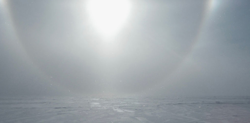
Atmospheric phenomenon such as this halo were common when the wind blew up ice crystals in the air.
Though being in the deep field was at times both incredible and deeply exciting, I don’t want to gloss over the hardships as is done oftentimes when relaying stories from the field. At times, the cold would be all-consuming to me, and by the end of the season, I sincerely longed for warmth, to not be worried almost constantly by the threat of the cold, to be able to walk normally without those huge boots on. At times, I longed for social connection, for my friends and family, for the reassurance of human touch, for the cheerful spirit of my cat, or for the security of my home that was oh-so-far away. At times, I would close my eyes and imagine what darkness and night looked like, and several times indeed dreamt of walking through lush green grass. Yet, when the time came to pack up camp, and when we finally loaded the LC-130 aircraft on January 22nd, 2020 to take us back to McMurdo Station, I felt sad to end this journey, to leave this time in the deep field, where we were doing incredible science, where life was simple, and where so much academic and personal growth had occurred.

The Hercules Dome team in the field just before boarding the Hercules LC-130 aircraft that took us back to McMurdo Station, after 28 days in the field. From left to right: Ben Hills, Nick Holschuh, Knut Christianson, John Christian, Andrew Hoffman, Gemma O'Connor, and me. Photo credit: Gemma O'Connor.
Through each point in our journey in Antarctica, I felt conscious that I was being put out of my comfort zone, that I was learning so much in many, many ways – about science, about Antarctica, about others, about myself. And that I truly felt that I was changing from this experience, an experience I know I will be forever grateful for. As the LC-130 rumbled off into the sky with us on board, departing Hercules Dome, the lyrics from a Lord Huron song kept replaying in my mind:
“I took a little journey to the unknown,
And I come back changed, I can feel it in my bones….
How long ... have I been away?
Oh, it feels like ages though you say it's only days
There ain't language for the things I've seen….
Say goodbye to who I was,
I ain't never been away so long,
Don't look back, them days are gone…”
Thanks for staying with me through this journey. I am incredibly grateful for the immense support of family, friends, and acquaintances. Until next time.
~Annika


Comments